
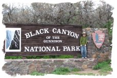
The Black Canyon of the Gunnison
Sunday-Wednesday, May 27th – 30th, 2007Some are longer, some are deeper, some are narrower, and few have walls as steep. But no other canyon in North America combines the depth, narrowness, sheerness and somber countenance of the Black Canyon of the Gunnison.
– Geologist Wallace Hansen
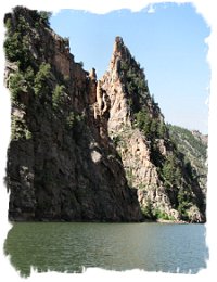
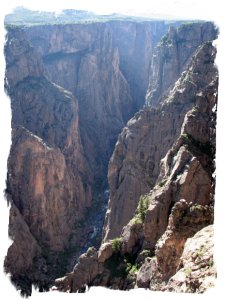 The thing about the Black Canyon of the Gunnison – it looks like a canyon should. The Grand Canyon is wonderful, (if a bit overwhelming). But it is so wide, and has so many side canyons, that it’s somewhat hard to make any sense of it.
Not so with the Black Canyon – it’s a deep, dark, narrow gash in the earth. “Whoa”, you say upon your first view, drawing back from the edge. If you had to point to the reference standard for canyons, this would be it.
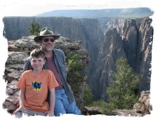
The park has only recently been ‘promoted’ from a National Monument to a National Park (1999), and as such, there isn’t that much development. We like that – other than a visitor center, campground, a 7 mile rim drive with overlooks and a few trails, there isn’t much here.
 For example, there isn’t an ‘official’ trail leading to the canyon floor inside the national park boundaries. You can hike down if you wish to make the 2000 foot descent, but you have to scramble down steep rock falls to do it. The rangers make a point to tell you if you get hurt, there isn’t much they can do other than come down and talk you into walking back out. It’s much too narrow for helicopter rescue, and the Gunnison River at the bottom is still a wild, powerful river, dropping an average of 96 feet per mile. If you choose to hike down, you are on your own.
Our surroundings were of the wildest possible description. The roar of the water ….was constantly in our ears, and the walls of the canyon, towering half mile in height above us, were seemingly vertical. Occasionally a rock would fall from one side or the other, with a roar and crash, exploding like a ton of dynamite when it struck bottom, making us think our last day had come – Abraham Lincoln Fellows (1901 surveying party)
The campground was a nice change from the commercial KOA campgrounds we have been staying in. We’re trying to alternate between private campgrounds with hookups, and public ones that don’t (although occasionally we’ll get lucky and find a state or national park campground with electricity). We can run for about 3 days reasonably comfortably off batteries and the amount of water the camper can store, so boondocking for short periods is fine. The campground is quiet, and we’ve had mule deer wandering through on a regular basis.
Water is limited – it must be hauled in from 15 miles away from Montrose, CO, as the only other water available is 2000 feet below in the canyon bottom. Nearby Montrose built a 5.8 mile long water diversion tunnel from the canyon floor in 1905 for irrigation, and is a lush oasis in an otherwise bleak landscape. Vance found the story of the surveying teams for the tunnel fascinating, as the team that was ultimately successful navigated the wild Gunnison River by inner-tube, after several other attempts by boat and foot had failed.
 The geologic story of the canyon is one of uplift and erosion – this is a theme that we will revisit constantly as we visit the next several parks on our agenda in southern Utah. Vance is getting a good dose of geology 101, and I’ve been pleased with how much he’s seemed to retain. The Jr. Ranger programs usually have at least one section on geology, and Black Canyon’s went into depth on how and why the canyon is so vertical, rather than spread out like other big canyons (in short, the river started cutting in a softer layer, when it hit hard rock it only could cut straight down at a rate of about 1 inch every 100 years. The softer upper layer later eroded away, leaving only the hard, black looking rock.)
Although the National Park contains the deepest sections of the canyon, only 14 miles of its 48 mile length are in the park. Much of the rest is included in the Curecanti National Recreation area, which includes 3 small lakes built in the upper canyon. We actually spent the bulk of our time in Curecanti, as the canyon is far more accessible there.
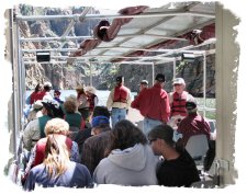 One of the highlights of our stay was a boat trip on Morrow Point Reservoir in the canyon. The Park Service provides pontoon boat tours of this section of the canyon. To reach the boat, you have to hike down a steep hill, then follow an old railroad bed for ½ mile. The Denver and Rio Grande Narrow Gauge railroad (the same one that goes through the bottom of Royal Gorge) attempted to push a line thru the canyon, in order to avoid the long, hard climbs over the adjacent passes. They made it as far as the present day location of the lakes.
At that point, the surveyors deemed the main portion of the canyon ‘inaccessible’. The rail line became quite the tourist destination, having the Slogan, “The Railroad of the World’. A drawing of the Curecanti Needle, a distinctive landmark in the canyon, became the logo for the railroad. Today, most of the old railbed is underwater, except for the portion we hiked down to the boat ride.
 The boat trip was awesome, as you experience the canyon from the bottom with a guided Ranger tour. The canyon remains narrow, so the soaring walls are nearby on both sides of the boat. We viewed several waterfalls, the Curecanti Needle, and the ranger highly recommended the Curecanti Creek hike, which descends one of the side canyons, with a waterfall at its mouth.
The next day we came back for the hike. It was a long drive – the boat tour is about 30 miles from our campground, and then you have to cross the canyon on top of the Blue Mesa Dam and circle back up on the north rim a ways. The hike was 4 miles round trip, descending about 1200 feet. It was interesting in that you could see the endpoint of the hike from an overlook – a sheer drop down the canyon wall.
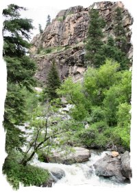 If I had to make a list of our 10 all time favorite hikes, this would be on the upper half of the list. About half way down, you join up with the roaring Curecanti Creek as it makes its rapid descent down to the lake at the bottom of the canyon. For close to a mile the trail runs right beside a long steep set of rapids. Because of the availability of water, the trail is lush in this area. Denise commented that it looked like something out of a Coors Beer commercial. It was unbelievably beautiful, with the waterfalls and soaring canyon walls. At the bottom, the creek comes down one last set of rapids before emptying into the lake – the spot we had viewed originally from high above.
Vance seems to have it all backwards hiking. He constantly complained going down that he couldn’t go a bit further. On the way back up (which was steep!) we constantly had to call out to him to wait up for us! We bumped into a gentleman hiking back up who we found out was a seasonal ranger who had just arrived at the park. He was out hiking the trails in the area to learn the territory before he started his job in a few days. This worked out great, as he gave us our own private ranger talk on the various trees along the trail as we hiked back out!
All in all this was a nice low-key visit to an ‘off the beaten path’ National Park. Black Canyon doesn’t get near the publicity or visitation of the nearby Grand Circle Parks (Mesa Verde, Arches, Bryce, Zion and Grand Canyon), but that was just fine with us. It’s an awesome canyon, and being able to see it from top to bottom using our own two feet was a great experience.

Vance: Black Canyon of the Gunnison was not always a national park. The first explorers had a hard time getting down into the canyon. One group was looking for a spot to build a water diversion tunnel. But on the first day, one of their boats was smashed and with it went most of the crew’s supplies. But the crew kept on for three weeks before giving up. Then the leader of the crew met another man and went farther down canyon. Instead of using boats, they used inflatable mattresses. After their success, the water diversion tunnel construction began. In 1933, President Herbert Hoover named the area Black Canyon of the Gunnison National Monument.
IN 1999, PRESIDENT BILL CLINTON CHANGED THE MONUMENT TO A NATIONAL PARK!
| Previous - Durango & Silverton RR | | Home | Index | | Utah Rocks - Next |


<< Home